Prev Page--Introduction || Next Page--Geology
Geography
Topography and Drainage
Graham County is entirely in the High Plains section of the Great Plains physiographic province (Adams, 1903, p. 113). The area does not consist of the flat to gently rolling upland plains typical of the High Plains farther west (Frye, 1945, p. 12; Prescott, 1954) but rather is moderately to well dissected. Most of the county is well drained and sloping ground predominates. The most extensive areas of flat land are on the terrace surface that is in the valley of South Fork Solomon River. This terrace is thought to be the same age as the Almena terrace along Prairie Dog Creek (Frye and Leonard, 1949, p. 53) and the Kirwin terrace on North Fork Solomon River (Leonard, 1952, p. 14). The lowest point in the county, which is where South Fork Solomon River enters Rooks County, is about 1,900 feet above sea level. Several places on the west side of the county have altitudes of more than 2,600 feet, the maximum altitude recorded during the leveling of wells and test holes being 2,633 feet at the SE cor. sec. 18, T. 9 S., R. 25 W. Thus the maximum relief is more than 700 feet.
South Fork Solomon River is the principal stream in Graham County. It flows across the center of the county from west to east and drains about two-thirds of the area. Bow Creek, which is intermittent in the western half of Graham County, flows northeasterly across the northern part of the county and continues easterly until it meets North Fork Solomon River in eastern Phillips County. The North Fork continues easterly and southeasterly and joins South Fork Solomon River south of Cawker City in Mitchell County, where it becomes the Solomon. Saline River flows southeastward through sec. 31, T. 10 S., R. 25 W., which is in the extreme southwestern corner of the county. The tributaries to Saline River drain approximately one-fourth of the county. Most of the tributaries to these three major streams are ephemeral--that is, they flow only during and after periods of heavy rain. However parts of some of the tributaries are spring-fed and maintain a small perennial flow.
Climate
The climate of Graham County is subhumid and is characterized by abundant sunshine, moderate precipitation, and a high rate of evaporation. Days are hot during the summer but the nights are generally cool. The summer heat is alleviated by good wind movement and low relative humidity. Winters are moderate with only occasional short periods of severe cold and with relatively light snowfall. The normal annual mean temperature at Hill City is 53.9° F. The highest normal monthly mean temperature is 79.0° F. in July and lowest normal monthly mean temperature is 28.5° F. in January. The lowest temperature on record at Hill City is -24° F., which occurred on January 12, 1912. The highest temperature on record is 117° F., which occurred on July 24, 1936. The average length of the growing season is 165 days but extremes of from 128 to 196 days have occurred.
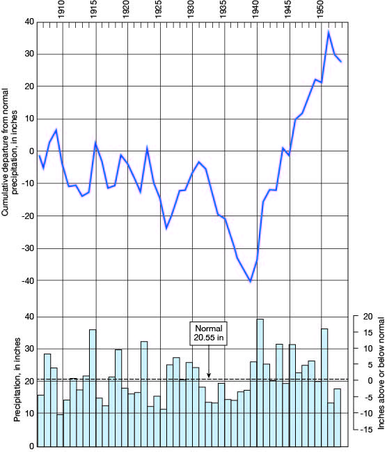
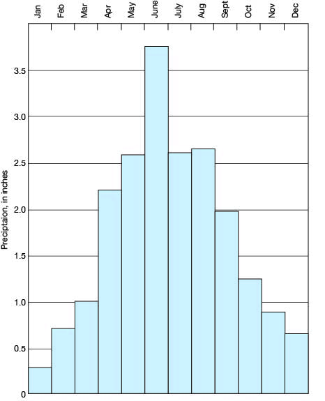
The norman annual precipitation at Hill City as determined by the U. S. Weather Bureau is 20.55 inches. The precipitation has ranged from a low of 9.65 inches in 1910 to a high of 39.38 inches in 1941. About 77 percent of the precipitation falls during the growing season from April through September when moisture is needed most. The annual precipitation and the cumulative departure from normal precipitation at Hill City for the period of record are shown in Figure 3 and the normal monthly precipitation is shown in Figure 4.
Figure 3--Graphs showing annual precipitation and cumulative departure from normal precipitation at Hill City.

Figure 4--Graph showing the normal monthly precipitation at Hill City.

Population
The population of Graham County in 1890 was 5,029, which was 9 more than the number recorded by the Federal Census of 1950. By 1910 the population had increased to 8,700, the greatest number ever recorded. The population decreased from 1910 to 1920, increased slightly from 1920 to 1923, and had decreased steadily since 1930 until the time of the 1950 census. A decrease from 6,071 to 5,020, or a 17.3 percent decrease, was recorded between 1940 and 1950. Probably the population at the present time (1953) is slightly greater than it was in 1950. The average density of population for the county in 1950 was 5.6 persons per square mile as compared to 23.2 for the State. [Note: Graham County population was listed as 2,946 in 2000 U.S. census, with a density of 3.3 (32.9 for the state) (KU Institute for Policy & Social Research).]
Hill City, the county seat of Graham County, had a population of 1,115 in 1940 and 1,432 in 1950 [1,604 in 2000]. Bogue had 157 inhabitants in 1940 and 211 in 1950 [179 in 2000]. Morland had 356 inhabitants in 1940 and 287 in 1950 [164 in 2000]. Graham County ranks 84th in population among the 105 counties in Kansas.
Transportation
Graham County is crossed by a branch line of the Union Pacific Railroad, which runs westward from Salina in Saline County to Colby in Thomas County. The railroad goes through Bogue, Hill City, Penokee, and Morland.
The county is traversed by two paved Federal highways--U. S. Highway 24 east-west just north of Bogue, Penokee, and Morland, and through Hill City and U. S. Highway 283 north-south through Hill City. State Highway 18, which is paved, parallels the railroad northwestward from the Rooks County line to Bogue where it turns northward to join U. S. Highway 24. Short sections of paved highway, State Highways 84 and 85, run north from Penokee and Morland, respectively, to U. S. Highway 24. Several of the county roads have been graded and graveled and many other county and township roads have been improved.
Agriculture
Agriculture is the principal occupation in Graham County, which according to a census of the State Board of Agriculture, in 1945 had 909 farms. In 1950, 192,824 acres of crops were harvested, approximately 70 percent of the crop land being devoted to the raising of wheat. About 40 percent of the land is in pasture and cattle raising is a major occupation. The acreage of principal crops grown in 1950 is shown in Table 1.
Table 1--Acreage of principal crops grown in Graham County in 1950. (Data from Kansas State Board of Agriculture)
| Crop | Acres | |
|---|---|---|
| Wheat | 136,000 | |
| Corn | 8,000 | |
| Oats | 2,220 | |
| Barley | 6,580 | |
| Rye | 150 | |
| Sorghum | ||
| For grain | 22,280 | |
| For forage | 12,060 | |
| For silage | 2,190 | |
| All hay | 3,320 | |
| Total | 192,800 | |
Mineral Resources
The principal mineral resources of Graham County in addition to ground water are oil and construction materials.
Oil
The first well in Graham County to find oil in commercial quantities was drilled by the Continental Oil Company in 1938 in the southeastern part of the county in sec. 15, T. 9 S., R. 21 W. Subsequent development has proved this well to be the discovery well of the largest pool in the county, the Morel. To the end of 1953, the 210 Arbuckle producing wells of the Morel pool had produced 16,631,864 barrels of oil (Ver Wiebe and others, 1954, p. 160). The second largest oil pool in the county, the Cooper, which in 1953 had more than 100 Arbuckle producing wells, was discovered during 1950. During the first four years, 3,119,535 barrels of oil were produced from this pool. In 1953, production was from 37 pools, 7 of which were discovered in that year. To the end of 1953 a total of 22,212,816 barrels of oil bad been produced from the 442 producing Graham County wells. The principal producing rocks in the county are the Lansing and Kansas City groups and the Arbuckle group. Data concerning the development and production of oil in the county are given by Ver Wiebe, 1940, 1941, 1942, 1943, 1944, 1945, 1946, and 1947 and Ver Wiebe and others, 1948, 1949, 1950, 1951, 1952, 1953, and 1954. [Current information on the oil and gas resources of Graham County is available from the KGS website.]
Construction materials
Rocks from the Ogallala and Niobrara formations have been used to some extent for construction in Graham County. The lower part of the Ogallala in places contains a distinctive hard green rock consisting of sand and gravel cemented with opaline silica (Pl. 3A). This rock (which is called "quartzite," has been used to build several buildings in the county (Pl. 3B) and was used for riprap on the upstream face of Antelope Lake dam in the NE sec. 9, T. 8 S., R. 25 W. Crushed quartzite has been used on several rural roads and was used in concrete pavement in Hill City (Byrne, Coombs, and Matthews, 1951, p. 13).
Plate 3--Quartzite of the Ogallala formation. A, Bed of very hard, fine-grained, green quartzite in the SW NW sec. 6, T. 9 S., R. 21 W. B, Building constructed of quartzite in picnic ground at Antelope Lake, sec. 9, T. 8 S., R. 25 W.

The Smoky Hill chalk member of the Niobrara formation has been used in the construction of buildings in Graham County. The formation is generally shaly but where it is more massive, building stone can be quarried (Pl. 4). Chalk has also been used on some of the roads. Other materials used in construction are ledges of mortar beds in the Ogallala formation which have been crushed and used on some roads and beds of unconsolidated sand and gravel which have been quarried at several localities from both the Ogallala formation and terrace deposits. Sand and gravel is obtained hydraulically from the alluvium of the South Fork Solomon River. For a more complete discussion of these and other materials whose economic value is minor the reader is referred to Byrne, Coombs, and Matthews (1951).
Plate 4--Niobrara formation. A, Smoky Hill chalk member consisting of a bed of massive yellow-brown chalk lying above blue-gray shale. B, Old house constructed of massive Smoky Hill chalk member or Fort Hays limestone member.

Prev Page--Introduction || Next Page--Geology
Kansas Geological Survey, Geology
Placed on web Feb. 13, 2009; originally published August 1955.
Comments to webadmin@kgs.ku.edu
The URL for this page is http://www.kgs.ku.edu/General/Geology/Graham/03_geog.html