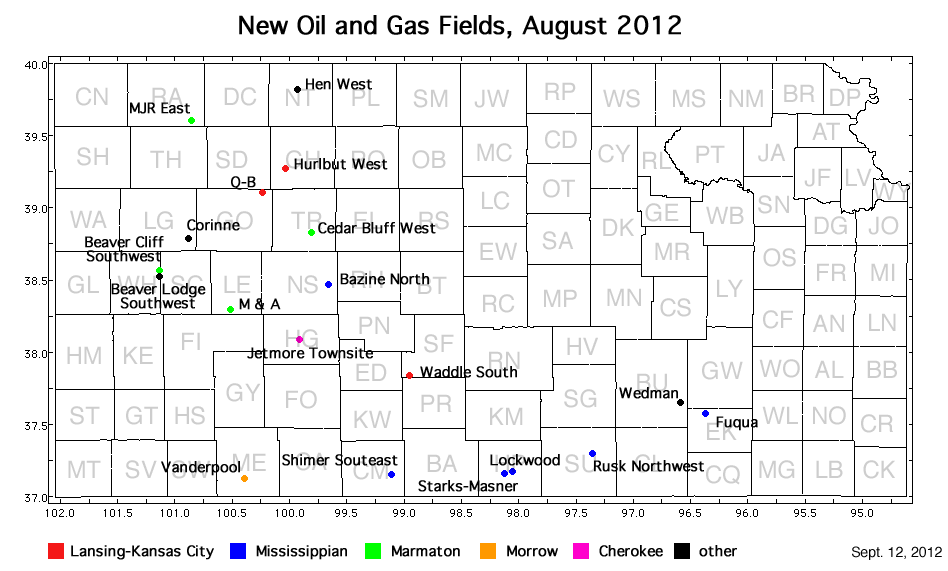
| Oil and Gas Fields Added, August 2012 | ||

| Field | Well | Operator | API Number | Latitude | Longitude | Location | Spot | Pay Zone |
|---|---|---|---|---|---|---|---|---|
| Bazine North | Slover 'J' 1 | Palomino Petroleum, Inc. | 15-135-25379 | 38.4625821 | -99.657198 | sec. 28, T. 18, S., R. 21 W. | SW SE NW NW | Mississippian |
| Beaver Cliff Southwest | Simons 'A' 1-24 | Ritchie Exploration, Inc. | 15-203-20170 | 38.5666508 | -101.13506 | sec. 24, T. 17, S., R. 35 W. | SW NW NE | Marmaton |
| Beaver Lodge Southwest | Earl Smith 1 | Ritchie Exploration, Inc. | 15-203-20173 | 38.5281059 | -101.13077 | sec. 36, T. 17, S., R. 35 W. | NW SE SE | Lansing-Kansas City and Marmaton |
| Cedar Bluff West | Reis 1-18 | Hess Oil Co. | 15-195-22781 | 38.8279267 | -99.809073 | sec. 18, T. 14, S., R. 22 W. | NW SW SW SE | Marmaton |
| Corinne | Corinne 1-33 | Lario Oil and Gas Co. | 15-109-21089 | 38.7885935 | -100.87687 | sec. 33, T. 14, S., R. 32 W. | SW NW SE SE | Lansing-Kansas City, Marmaton, Cherokee, and Penn Basal |
| Fuqua | Fuqua 9-36 | Layne Energy Operating, LLC | 15-049-22559 | 37.5681345 | -96.366279 | sec. 36, T. 28, S., R. 9 E. | N2 S2 N2 SE | Mississippian |
| Hen West | Miller 1-5 | Crawford Oil & Gas Co. LLC | 15-137-20589 | 39.8193242 | -99.929745 | sec. 5, T. 3, S., R. 23 W. | SW NW NE SE | unknown |
| Hurlbut West | Keith-Ficken 17-1 | H & C Oil Operating Inc. | 15-065-23835 | 39.2660433 | -100.03005 | sec. 17, T. 9, S., R. 24 W. | NW NE SW SW | Lansing-Kansas City |
| Jetmore Townsite | RJD Unit 1 | White Exploration, Inc. | 15-083-21713 | 38.0875798 | -99.909546 | sec. 1, T. 23, S., R. 24 W. | NE NW NE NW | Cherokee |
| Lockwood | Lockwood Farms 3307 14-1H | Shell Gulf of Mexico Inc. | 15-077-21772-0100 | 37.1674065 | -98.055881 | sec. 14, T. 33, S., R. 7 W. | E2 SW SW SW | Mississippian |
| M & A | M & A Trust 1 | Raymond Oil Co., Inc. | 15-101-22350 | 38.2903106 | -100.51603 | sec. 27, T. 20, S., R. 29 W. | NE SE NW NW | Marmaton |
| MJR East | Anderson-Ryan 1-19 | Murfin Drilling Co., Inc. | 15-153-20897 | 39.6052359 | -100.84724 | sec. 19, T. 5, S., R. 31 W. | W2 SW SE NW | Marmaton |
| Q-B | Q-B 1-17 | Grand Mesa Operating Co. | 15-063-21990 | 39.0995279 | -100.23193 | sec. 17, T. 11, S., R. 26 W. | NE NE SE NW | Lansing-Kansas City |
| Rusk Northwest | Boxcar 1 | CMX, Inc. | 15-191-22636 | 37.2922782 | -97.350481 | sec. 6, T. 32, S., R. 1 E. | SW NE SE SE | Mississippian |
| Shimer Southeast | Gregg 1-30 | Castelli Exploration, Inc. | 15-033-21634 | 37.1443318 | -99.107893 | sec. 30, T. 33, S., R. 16 W. | NE SW SW NW | Mississippian |
| Starks-Masner | Starks & Masner 3307 30-1H | Shell Gulf of Mexico Inc. | 15-077-21774-0100 | 37.1508262 | -98.11922 | sec. 30, T. 33, S., R. 7 W. | SE NW NW NE | Mississippian |
| Vanderpool | Vanderpool 1-5 | O'Brien Energy Resources Corp. | 15-119-21317 | 37.1169283 | -100.39106 | sec. 5, T. 34, S., R. 28 W. | SW NE NE SW | Morrow |
| Waddle South | Stallings-Gartung Unit 1-35 | L. D. Drilling, Inc. | 15-185-23754 | 37.8308999 | -98.948548 | sec. 35, T. 25, S., R. 15 W. | SW NW NW SW | Lansing-Kansas City |
| Wedman | Wedman Unit 1-6 | Eagle Creek Corp. | 15-015-23933 | 37.6442955 | -96.588376 | sec. 6, T. 28, S., R. 8 E. | NW | Simpson |
|
Kansas Geological Survey, Oil and Gas Information Updated Sept. 13, 2012 Comments to webadmin@kgs.ku.edu The URL for this page is http://www.kgs.ku.edu/Magellan/Field/NMC/aug_2012.html |