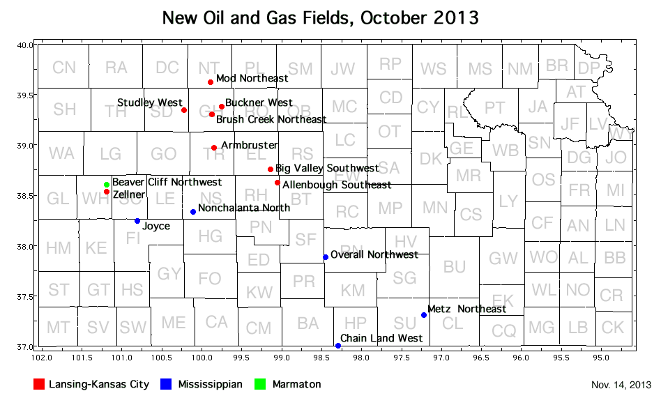
currently headed by John Morrison of the Independent Oil and Gas Service, Wichita.
| Oil and Gas Fields Added, October 2013 | ||
| Fields are named by the Kansas Geological Society's Nomenclature Committee, currently headed by John Morrison of the Independent Oil and Gas Service, Wichita. |
||

| Field | Well | Operator | API Number | Latitude | Longitude | Location | Pay Zone |
|---|---|---|---|---|---|---|---|
| Allenbough | Schneider 1-36 | Samuel Gary Jr. and Assoc., Inc. | 15-165-22031 | 38.6197462 | -99.0491009 | sec. 36, T. 16 S., R. 16 W. | Lansing-Kansas City |
| Armbruster | Armbruster 1-35 | Samuel Gary Jr. and Assoc., Inc. | 15-195-22867 | 38.9642804 | -99.8407494 | sec. 35, T. 12 S., R. 23 W. | Lansing-Kansas City |
| Beaver Cliff Northwest | Jjard 1735 1-4 RE | SandRidge Exploration and Production LLC | 15-203-20059-0001 | 38.6001239 | -101.1853537 | sec. 4, T. 17 S., R. 35 W. | Marmaton |
| Big Valley Southwest | Brungardt 1 | American Land And Energy LLC | 15-051-26588 | 38.7558712 | -99.1369703 | sec. 7, T. 15 S., R. 16 W. | Lansing-Kansas City |
| Brush Creek Northeast | Carl Quint 1-3 | Downing-Nelson Oil Co Inc | 15-065-23915 | 39.2992517 | -99.8693998 | sec. 3, T. 9 S., R. 23 W. | Lansing-Kansas City |
| Buckner West | Griffith Unit 2-1 | H & C Oil Operating Inc. | 15-065-23965 | 39.3819156 | -99.7515347 | sec. 2, T. 8 S., R. 22 W. | Lansing-Kansas City |
| Chain Land West | Teresia 3509 1-16 | SandRidge Exploration and Production LLC | 15-077-21797 | 36.9985578 | -98.293728 | sec. 16, T. 35 S., R. 9 W. | Mississippian |
| Joyce | Joyce Trust 2132 1-11 | SandRidge Exploration and Production LLC | 15-055-22223 | 38.2419832 | -100.8093632 | sec. 11, T. 21 S., R. 32 W. | Mississippian |
| Metz Northeast | Neises Trust 4-11-4-14H | Source Energy MidCon LLC | 15-191-22676-0100 | 37.3030079 | -97.2204485 | sec. 4, T. 32 S., R. 2 E. | Mississippian |
| Mod Northeast | Hager Trust 1-11 | Samuel Gary Jr. and Assoc., Inc. | 15-137-20657 | 39.6288973 | -99.887753 | sec. 11, T. 5 S., R. 23 W. | Lansing-Kansas City |
| Nonchalanta North | Pete 1 | Palomino Petroleum, Inc. | 15-135-25633 | 38.3313781 | -100.1106639 | sec. 8, T. 20 S., R. 25 W. | Mississippian |
| Overall Northwest | Loudenback 7-1H | Unit Petroleum Co. | 15-155-21662-0100 | 37.8822607 | -98.4564252 | sec. 18, T. 25 S., R. 10 W. | Mississippian |
| Studley West | Archer 21-1 | IA Operating, Inc. | 15-179-21328 | 39.3418056 | -100.2198315 | sec. 21, T. 8 S., R. 26 W. | Lansing-Kansas City |
| Zellner | Zellner 1-33 | Lario Oil and Gas Co. | 15-203-20228 | 38.5334031 | -101.185556 | sec. 33, T. 17 S., R. 35 W. | Lansing-Kansas City |
(Lone Tree field in McPherson County was created in error and has been removed.)
|
Kansas Geological Survey, Oil and Gas Information Updated Nov. 18, 2013 Comments to webadmin@kgs.ku.edu The URL for this page is http://www.kgs.ku.edu/Magellan/Field/NMC/oct_2013.html |