KGS Home Page Oil and Gas Index Page County Production Page

Barber County--Oil and Gas Production


Production


Year Oil Gas
Production
(bbls)
Wells Cumulative
(bbls)
Production
(mcf)
Wells Cumulative
(mcf)
1995 536,988 666 58,020,250 11,414,164592 1,335,289,342
1996 523,279 674 58,543,529 11,834,046652 1,347,123,388
1997 503,154 655 59,046,683 11,415,877663 1,358,539,265
1998 449,387 608 59,496,070 11,329,113664 1,369,868,378
1999 470,148 612 59,966,218 10,969,623681 1,380,838,001
2000 473,796 631 60,440,014 11,522,597697 1,392,360,598
2001 463,363 654 60,903,377 10,824,095704 1,403,184,693
2002 515,919 666 61,419,296 10,334,974734 1,413,519,667
2003 476,341 766 61,895,637 9,954,157760 1,423,473,824
2004 545,302 808 62,440,939 10,953,913805 1,434,427,737
2005 615,047 729 63,055,986 12,287,786893 1,446,715,523
2006 763,963 800 63,819,949 13,998,673940 1,460,714,196
2007 1,057,501 837 64,877,450 15,360,1321048 1,476,074,328
2008 1,397,824 936 66,275,274 17,720,5421142 1,493,794,870
2009 1,615,794 976 67,891,068 17,403,9511198 1,511,198,821
2010 1,822,698 1062 69,713,766 19,990,8591249 1,531,189,680
2011 1,917,025 1165 71,630,791 21,978,2641357 1,553,167,944
2012 2,253,941 1278 73,884,732 26,115,5921464 1,579,283,536
2013 2,356,338 1396 76,241,070 28,464,4321495 1,607,747,968
2014 2,059,343 1485 78,300,413 27,760,9821562 1,635,508,950
2015 1,652,323 1447 79,952,736 24,957,9921585 1,660,466,942
2016 1,142,514 1475 81,095,250 20,003,0531551 1,680,469,995
2017 947,643 1480 82,042,893 17,125,4551480 1,697,595,450
2018 793,477 1435 82,836,370 14,911,0741466 1,712,506,524
2019 695,874 1388 83,532,244 12,736,5101432 1,725,243,034
2020 546,915 1304 84,079,159 10,249,0931363 1,735,492,127
2021 611,542 1235 84,690,701 9,978,5241309 1,745,470,651
2022 973,488 1220 85,664,189 10,150,1371308 1,755,620,788
2023 851,808 1163 86,515,997 9,922,9181255 1,765,543,706
2024 449,302 1070 86,965,299 5,321,0521199 1,770,864,758
Updated through 7-2024.
Note: bbls is barrels; mcf is 1000 cubic feet.

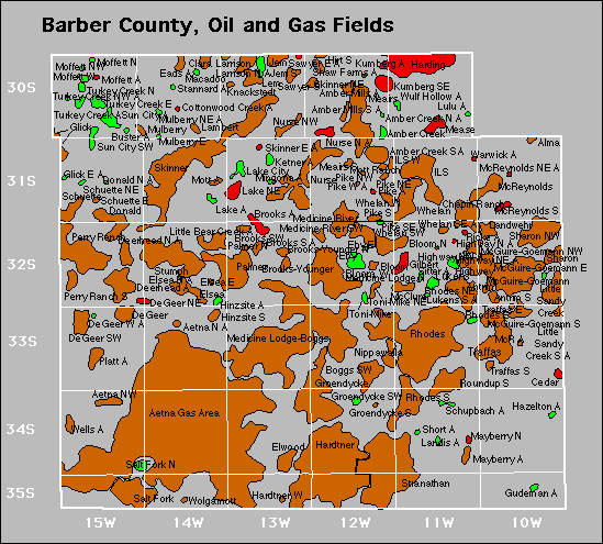
County Map

Barber County oil and gas map
oil=green, gas=red, oil and gas=brown

Fields

Also available is a text file containing field summary data for all fields in this county.
Active
Aetna Gas Area
Aetna North
Aetna Northwest
Alma
Amber Creek
Amber Creek East
Amber Creek North
Amber Creek South
Amber Creek Southeast
Amber Mills
Amber Mills South
Antrim
Antrim South
Bloom
Bloom North
Bloom West
Boggs Southwest
Brooks
Brooks North
Brooks South
Brooks Southwest
Brooks-Younger
Brooks-Younger North
Buster
Catlin
Cedar
Chain
Chapin Ranch
Clara
Cottage Creek
Cottonwood Creek
Dalaw
Deadman Draw
Deerhead
Deerhead North
Degeer
Degeer Northeast
Degeer Southwest
Donald
Donald North
Donald Northeast
Eads
Eby
Eby East
Elsea
Elsea East
Elsea North
Elwood
Gilbert
Glick
Groendycke
Groendycke South
Groendycke Southwest
Gudeman
Gudeman Southeast
Gudeman Southwest
Hallelujah
Harding
Hardtner
Hardtner West
Hazelton
Hazelton Townsite
Hazelton Townsite South
Hazelton Townsite Southwest
Highway
Highway Northeast
Hinzsite
Hinzsite South
Hirt South
Ils
Ils West
Jem
Jem South
Ketner East
King James
Kiowa
Kiowa South
Kiowa Townsite
Kiowa Townsite Southwest
Knackstedt
Knackstedt West
Knorp
Knorp Southwest
Kochia
Kristi
Kumberg
Kumberg Southeast
Lake
Lake City
Lake City East
Lake Northeast
Lambert
Landis
Landwehr
Larrison
Larrison South
Lee Ranch
Lem
Little Bear Creek
Little Sandy Creek
Little Sandy Creek South
Lukens
Lukens South
Macadoo
Macadoo South
Maryhall
Mayberry
Mayberry East
Mayberry North
Mayberry Northwest
Mcclure
Mcguire-Goemann
Mcguire-Goemann Northwest
Mcguire-Goemann South
Mcreynolds
Mcreynolds Northeast
Mcreynolds South
Meairs
Meairs South
Mease
Medicine Lodge North
Medicine Lodge-Boggs
Medicine River
Medicine River Southwest
Medicine River West
Minefield
Mingona
Moffett
Moffett North
Moffett Northwest
Moffett West
Mott
Mott Ranch
Mulberry
Mulberry East
Mulberry Northeast
Nippawalla
Nurse
Nurse North
Nurse Northwest
Palmer
Palmer North
Perry Ranch
Perry Ranch South
Pike
Pike Northeast
Pike Northwest
Pike South
Pike Southeast
Pike West
Platt
Platt Northeast
Platt South
Platt Southwest
Platt West
Rhodes
Rhodes East
Rhodes Northeast
Rhodes South
Ricke
Roundup South
Salt Fork
Salt Fork North
Salty Creek
Salty Creek West
Sawyer
Sawyer East
Sawyer South
Schuette
Schuette East
Schuette Northeast
Schupbach
Schupbach Southeast
Schupbach Southwest
Sharon
Sharon Northwest
Shaw Farms
Short
Sitter
Skinner
Skinner East
Skinner Northeast
Skinner West
Spicer
Spivey-Grabs-Basil
Stannard
Stannard Southeast
Stranathan
Stranathan East
Stranathan Northeast
Stumph
Sun City
Sun City Northeast
Sun City Southwest
Toni-Mike
Toni-Mike Northeast
Traffas
Traffas East
Traffas South
Turkey Creek
Turkey Creek East
Turkey Creek North
Turkey Creek Northwest
Wells
Wells North
West Ridge
Whelan
Whelan South
Whelan Southeast
Whelan Southwest
Whelan West
Wolgamott
Wulf Hollow

Abandoned

Degeer West
Glick East
Highway North
Highway Northwest
Ketner
Lulu
Mcr
Warwick


Kansas Geological Survey
Comments to webadmin@kgs.ku.edu
URL=http://www.kgs.ku.edu/PRS/County/abc/barber.html
Data from Kansas Dept. of Revenue files monthly.