User's Guide to the Dakota Aquifer in KansasAllen Macfarlane, John Doveton, and Donald WhittemoreTechnical Series 21998 56 pages, 44 figures, a glossary, suggested readings, and a list of information sources |
 |
| A full online version of this publication is not available. Copies of this publication are available from the publications office of the Kansas Geological Survey (785-864-3965). The cost is $10 per copy, plus sales tax, shipping, and handling. | |
Figure 1--Limit of Dakota aquifer in North America.
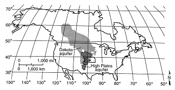
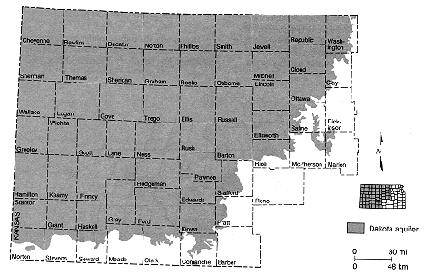
Figure 2--Extent of Dakota aquifer in Kansas.
Dakota Aquifer Program
Even though the Dakota has been used as a source of water for more than a century in Kansas, its hydrologic character has been poorly understood and the issues surrounding its use have been inadequately addressed. A decade ago, State and local agencies recognized the localized depletion of the High Plains (Ogallala) aquifer and stream-aquifer systems in western and central Kansas and the need to identify other sources that might replenish available supplies. Little was known about either the quantity or the quality of ground water or the impact of regional or local development on the Dakota that could be used to guide regional or local planning until recently. This focused the attention of the water agencies on the Dakota, a deeper and more complex sandstone aquifer system. Concerns related to human activity also were expressed, such as the potential hazards of disposing oil-brine in shallow zones beneath the Dakota in central Kansas and the protection of usable ground-water resources in the Dakota. Kansas has had oil-well surface casing and cementing standards for protecting shallow fresh ground water since the 1960's.In response, the Kansas Geological Survey began an eight-year investigation into the hydrogeology and water quality of the Dakota in 1988. Goals of the program were to assess the water-resources potential of the Dakota aquifer and to assist the agencies in the development of appropriate management plans and policies. This program was unique because it was designed for proactive rather than reactive water-resources management of a regional aquifer system. The broad objectives of the program were to (1) characterize the geologic framework of the Dakota aquifer; (2) define the ground-water-flow system within the aquifer to identify sources of recharge, discharge, flow path, and areas of interaction with other aquifer systems; (3) assess the water quality of the Dakota aquifer; and (4) assess the impact of current and future development in the Dakota and interacting aquifer systems, including the impact of oil-field-brine disposal in the underlying Permian on the Dakota aquifer in the areas of aquifer interaction.
Purpose and Organization
Historically, the Dakota aquifer has generally been poorly understood in Kansas. Because of its complexity and limited use, our poorly documented experience with this source of water contains some truths but many misconceptions about the Dakota that have continued to the present. The purpose of this book is to educate Kansans about the Dakota aquifer as we know it today. It is written primarily for a nontechnical to semi-technical audience and is designed to provide the reader with a basic understanding of the Dakota aquifer and the issues surrounding its use as a water resource. Where the discussion becomes more technical, every effort has been made to explain the concepts in less technical language. Also, a Glossary of the terms used in this report is contained in Appendix 1. During the initial stages of this project, it became obvious to us that the complexity of the Dakota warranted this type of publication to help guide those interested in the water resources of this aquifer system.The user's guide contains two major sections. Part 1 describes the hydrogeology and water quality of the Dakota, and Part 2 is a discussion of its water resources. Because much of the information in Part 1 forms the background for the ensuing discussion in Part 2, readers are urged to read the sections in order of their presentation. The reader will also find a listing of agencies that will have information on the Dakota aquifer (Appendix 2) and the publications from the Dakota Aquifer Program (Appendix 3). Additional technical information on the Dakota aquifer can be found on the Kansas Geological Survey home page. The World Wide Web address is http://www.kgs.ku.edu/. A bulletin on the Dakota also is planned and should provide considerable additional information to those seeking technical guidance. Some of the more general publications of the Dakota Aquifer Program are listed on the inside front cover of this publication.