New Book About Risk In The Oil Business
To find oil, first you need to know the underground geology. To take the
next step—deciding which wells to drill and which to avoid—requires
a knowledge of cash flow and finance.
Taking that next step in making exploration decisions is the focus of
a new book co-authored by John Davis, a Survey specialist in the mathematics
of geology; John Harbaugh, of Stanford University; and Johannes Wendebourg,
of the Institut Français du Pétrole in France. Computing
Risk for Oil Prospects, published by Pergamon Press, provides explorationists
the mathematical techniques and computer programs for comparing the risks
and return.
The book contains chapters on estimating the amount of oil in a field,
estimating field size, using seismic data and other mapped information,
forecasting cash flow over time, and analyzing risk. It includes two floppy
disks of computer programs for risk analysis and calculating the expected
financial returns from drilling. “There’s lots of information
available to explorationists, if it’s used appropriately,”
said Davis. “The goal of this book is to help people better appraise
prospects before they are drilled.”
Russell County Geologic Map and Report
Nearly 100 million years worth of geology, on display in the rocks of
Russell County, is described in a new report and geologic map now available
from the Kansas Geological Survey. The full-color map and report are by
geographers William Johnson at Kansas University and Alan Arbogast, a
former KU geography graduate student, now teaching at Michigan State University.
Because Russell County is one of the state’s leading producers
of petroleum, geologists already know much about the deep underground
geology of the county. The new map and report focus more on the geology
at the earth’s surface, showing the type of bedrock in Russell County.
Maps of near-surface geology are a beginning point in planning, construction,
location of natural resources such as water or building stone, and a variety
of environmental activities. The Russell County map is one in a series
of new geologic maps being produced by the Survey.
The map is drawn at a scale of 1:50,000 (one inch on the map equals about 0.8 of a mile). Copies of the new map and report are available from the KGS. The cost is $15.00 for the map, $10.00 for the report, plus tax and shipping from the KGS.
New
Publications
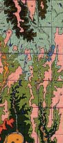
Segment of Russell County Geologic Map.
The
Kansas Geological Foundation has over 100 videotapes on earth-science
topics available for loan to schools, civic and professional organizations,
geologists, and individuals. Topics include dinosaurs, disasters and geologic
hazards, environment, archeology, industry, mineralogy, paleontology,
stratigraphy, structural geology, technology, and general interest. Most
tapes are for non-technical audiences, but a few are more technical in
nature.
Videotapes may be checked out through the Kansas Geological Society Library
in Wichita for two weeks; the only cost to the borrower is return postage.
Tapes also may be viewed at the George Bruce Resource Center at the library.
A large-screen projector is available for use by schools and organizations
in the Wichita area.
Contact Janice Bright at the library (316-265-8676), or write the Kansas Geological Foundation, Landmark Square, 212 North Market Street, Wichita, Kansas 67208. A complete list of tapes with brief descriptions is available upon request.
Earth Science Videos
URL:http://www.kgs.ku.edu/Publications/GeoRecord/1996/vol2.2/Page3.html