A Place to Visit
Elk Falls
![]()
Elk County,
Kansas

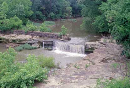
Every once in a while, just when you think you know the Kansas landscape, it springs a surprise. Elk Falls is on the east edge of the town by the same name. Here the Elk River drops four to six feet over the Elgin sandstone (for more about the geology of the area, see the Survey’s new geologic map of Elk County, described in this issue of The Geologic Record). A rock wall near the falls is evidence of a mill that once stood here, and downstream from the waterfall stands a majestic iron bridge, built in 1893, that is now on the national register of historic places. This waterfall is publicly accessible.

Kansas Geological Survey
1930 Constant Avenue, Campus West
Lawrence, Kansas
66047-3726
(785) 864-3965
-
Tom Collinson, Chair, Pittsburg
-
Robert Crangle, Lincoln
-
Dyan Jones, Prairie Village
-
David J. Heinemann, Topeka
-
Jeffrey Mason, Goodland
-
Dennis McKinney, Greensburg
-
Stephen Morris, Hugoton
-
David Nance, Pittsburg
-
Marvin Odgers, Sublette
-
Larry J. Richardson, Wichita
-
John K. Strickler ,Manhattan
-
William W. Hambleton, Emeritus Member, Lawrence
-
A. Scott Ritchie, KU Geology Assoc. Rep., Wichita
Director: Lee C. Gerhard
The mission of the Kansas Geological Survey, operated by the University of Kansas in connection with its research and service program, is to conduct geological studies and research and to collect, correlate, preserve, and disseminate information leading to a better understanding of the geology of Kansas, with special emphasis on natural resources of economic value, water quality and quantity, and geologic hazards.
The Geology Extension program furthers the mission of the KGS by developing materials, projects, and services that communicate information about the geology of Kansas, the state's earth resources, and the products of the Kansas Geological Survey to the people of the state
Online February 10, 2003
Comments to: lbrosius@kgs.ku.edu
Kansas Geological Survey
URL:http://www.kgs.ku.edu/Publications/GeoRecord/1997/vol3.3/Page4.html