Ground Water in Northeast
Kansas
Northeastern Kansas was covered by glaciers during the Ice Ages nearly
600,000 years ago. Today, the ice is gone, but the deposits they left
behind can be a valuable source for ground water.
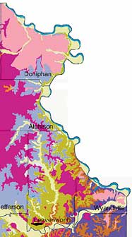
A new technical publication from the Kansas Geological Survey, Hydrogeology
and Geochemistry of Glacial Deposits in Northeastern Kansas by Jane
E. Denne, Rachel E. Miller, Lawrence R. Hathaway, Howard G. O’Connor,
and William C. Johnson, describes ground-water availability and quality
for all or parts of Nemaha, Brown, Doniphan, Atchison, Jackson, Jefferson,
Leavenworth, Wabaunsee, Shawnee, Douglas, Wyandotte, and Johnson counties.
The report includes a detailed map showing the topography of the area’s
bedrock, information that is particularly helpful when picking locations
to drill water wells. This report will be useful to communities and consultants
who are searching for high-capacity wells. It provides technical information
that can help guide water use in an area that is growing in population
and industry.
Copies of the report, Hydrogeology and Geochemistry of Glacial Deposits
in Northeastern Kansas (KGS Bulletin 229), are available from the
Kansas Geological Survey for $25.00 plus tax, shipping, and handling.
Sodium and Salinity in Kansas Soils
Salt marshes are not the only places with soils high in salts. A total
of 84 counties in Kansas contain at least one soil series that may be
affected by sodium or salinity.
A study by Philip E. Reed and Curtis J. Sorenson of The University of
Kansas, Potential for Sodium and Salinity in the Soil-survey Mapping
Units of Kansas, identifies more than one million acres of soils
in Kansas (less than 2% of the total area of the state) that are affected
by sodium or salinity. Sodium and salinity in these soils occurs naturally
rather than as a result of human-caused contamination. Being able to identify
these soils has important implications for soil-management practices.
Copies of this report (Technical Series 10) are available from the Survey
for $10 plus tax, shipping, and handling.
Chase Group Studied
Studying rocks in the Flint Hills can help geologists find gas in the
largest natural gas field in North America. Rocks that produce gas in
the giant Hugoton gas field in southwestern Kansas are exposed at the
surface in east-central Kansas. These strata, called the Chase Group by
geologists, were deposited during the Permian Period, about 280 million
years ago.
Outcrop Stratigraphy and Depositional Facies of the Chase Group (Permian,
Wolfcampian) in Kansas and Southeastern Nebraska, written by S. J.
Mazzullo, C. S. Teal, and C. A. Burtnett of Wichita State University,
examines regional aspects of the stratigraphy and depositional environments
of the Chase Group based on detailed description and correlation of 196
outcrops (measured sections) in Kansas and Nebraska. Studying Chase Group
outcrops is relevant to a better understanding of the reservoirs that
produce gas in the Hugoton field.
Copies of KGS Technical Series 6, Outcrop Stratigraphy and Depositional Facies of the Chase Group (Permian, Wolfcampian) in Kansas and Southeastern Nebraska, are available from the Survey for $30 plus tax, shipping, and handling.
New
Publications

Segment of Geologic Map of Northeastern Kansas from Bulletin 229.
A new program is helping Kansas teachers bring water education to the state’s classrooms. Project WET (Water Education for Teachers) provides information and teaching exercises about a variety of water-related topics, including the atmosphere, surface and ground water, chemistry, water history, watersheds, aquatic wildlife, water economics, water rights, and water conservation and stewardship. The program, tailored for K-12 and informal educators, is available through the Kansas Association for Conservation and Environmental Education (KACEE). It is sponsored by the Kansas Water Office and Kansas Water Authority with funding primarily from the State Water Plan fund. Project WET materials are only available to teachers who have completed a Project WET workshop, a number of which are being held across the state. For more information, contact KACEE at 785-532-3314.
Water
Education for Teachers
Project WET provides information and teaching exercises about a variety of water-related topics
URL:http://www.kgs.ku.edu/Publications/GeoRecord/1998/vol4.2/Page3.html