A Place to Visit
Cedar Bluffs Reservoir
![]()
Trego County,
Kansas

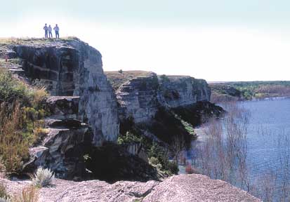
The rocky cliffs of Cedar Bluff provide a dramatic view over Cedar Bluff Reservoir on the Smoky Hill River in Trego County. The bluffs themselves are composed of thick layers of the Fort Hays Limestone, deposited during the Cretaceous Period, about 80 million years ago. The reservoir was constructed in 1951 by the Bureau of Reclamation, and was nearly dry during the 1970’s and 1980’s because of low flow in the Smoky Hill. Rains in 1993 raised water levels, bringing the lake to near the bottom of the bluffs. To reach the bluffs from I-70, take K-147 south from Ogallah, go about 3.5 miles south from the south end of the Cedar Bluff Dam, then turn west on County Road 1979. Follow the road west and north for 7 miles, turn north for 1 mile, then back to the east to Cedar Bluff. Photo by Robert Sawin.

Kansas Geological Survey
1930 Constant Avenue, Campus West
Lawrence, Kansas
66047-3726
(785) 864-3965
-
Tom Collinson, Chair, Pittsburg
-
Robert Crangle, Lincoln
-
Dyan Jones, Prairie Village
-
Sheila Leiker-Page, Victoria
-
Jeffrey Mason, Goodland
-
Dennis McKinney, Greensburg
-
Stephen Morris, Hugoton
-
Larry J. Richardson, Wichita
-
John K. Strickler, Manhattan
-
William Hambleton, Emeritus Member, Lawrence
-
A. Scott Ritchie, KU Geology Assoc. Rep., Wichita
Director: Lee Allison
The mission of the Kansas Geological Survey, operated by the University of Kansas in connection with its research and service program, is to conduct geological studies and research and to collect, correlate, preserve, and disseminate information leading to a better understanding of the geology of Kansas, with special emphasis on natural resources of economic value, water quality and quantity, and geologic hazards.
The Geology Extension program furthers the mission of the KGS by developing materials, projects, and services that communicate information about the geology of Kansas, the state's earth resources, and the products of the Kansas Geological Survey to the people of the state
Online February 10, 2003
Comments to: lbrosius@kgs.ku.edu
Kansas Geological Survey
URL:http://www.kgs.ku.edu/Publications/GeoRecord/2000/vol6.3/Page4.html