Winter 2002
Vol. 8.1
| |
||
| Kansas Geological Survey | Winter 2002 |
Vol. 8.1 |
|
Ogallala Aquifer
CONTENTS Ogallala Aquifer–page 1 Earth Science Teacher Honored–page 4
|
Declining
water levels in the Ogallala aquifer have gotten increasing attention
lately. Although most Kansans agree that something must be done to preserve
the Ogallala, the main water source for much of western Kansas, any plan
to conserve this crucial resource must take into account complex issues
and divergent viewpoints. Reaction to Governor Bill Graves' 2001 State of the State proposal, that
we stop depleting the state's aquifers by the year 2020, highlights the
range of opinion. While many said the 2020 goal for zero depletion—to
take no more water from the aquifer than is replenished by rainfall and
streamflow—would destroy the western Kansas economy, others argued
the goal wasn’t enough to preserve the aquifer for future generations.
About the only thing that no one disputes is that the Ogallala contains
a finite amount of water. The Ogallala is part of a larger aquifer system,
the High Plains aquifer, that extends under eight states in the Great
Plains. Measurements of ground-water levels in Kansas indicate that much
of the Ogallala has declined since the onset of large-scale irrigation
in the 1950's and 1960's. Based on past usage trends, researchers at the Kansas Geological Survey
made projections about the aquifer's usable lifetime, which varies considerably
from place to place. Although many parts of the aquifer should be able
to support pumping for 100 years or more, some parts are already effectively
exhausted: they've dropped below 30 feet of saturated thickness, the minimum
amount considered necessary to support large-scale pumping. Other parts
will be exhausted in the next 25 years. Despite the complex nature of both the problem and potential solutions,
some progress has been made towards developing a plan to conserve the
aquifer's remaining water. Two advisory committees appointed by the Kansas
Water Office developed recommendations that were finalized in a report
released in the fall of 2001. The committees, a management and a technical
advisory committee, were made up largely of people from western Kansas
and included staff from the KGS, Kansas Water Office, Division of Water
Resources (Kansas Department of Agriculture), Kansas State University,
Kansas Department of Commerce and Housing, U.S. Geological Survey, and
local Groundwater Management Districts (GMDs). "The report is a classic exercise in public decision making on a
complicated and fundamentally important issue," said technical advisory
committee member Wayne Bossert, manager of the Northwest Kansas GMD. "Somehow
we’ve got to get all the issues out there, and let the majority
of Kansans make a decision. This report is a pretty good effort at that." Chief among the report's recommendations was a proposal to divide the
aquifer into subunits. These aquifer subunits would be managed differently
based on their different characteristics—the saturated thickness
of the subsurface sediments, how easily they transmit water, and the rate
at which they are replenished by precipitation and streamflow. The three
western Kansas GMDs, locally managed political subdivisions, would be
responsible for delineating the subunits within their districts. To help the GMDs in this task, KGS water researchers are compiling and
evaluating a range of data, including best estimates of aquifer recharge,
ground-water levels, water usage, and climate trends for different parts
of the aquifer. The report also recommended using incentive-based programs (such as federal funds to buy and retire water rights) and improvements in technology and education to promote conservation and help extend the life of the aquifer. An educational resource center, the Ogallala Aquifer Institute, would further the educational part of these recommendations. The Institute is located at the Finnup Center for Conservation Education in Garden City, Kansas, and will provide education support activities for schools as well as adult education opportunities.
The Kansas Water Authority approved these recommendations for inclusion in the draft 2004 State Water Plan, the blueprint for managing the state’s water resources. The recommendations will be discussed during the March meetings of the 12 Basin Advisory Committees.
|
|
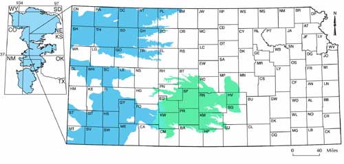
Extent of the Ogallala aquifer (shaded blue) within
the High Plains aquifer in Kansas. The Ogallala does not include the portion
of the High Plains aquifer in south-central Kansas (shaded green). |
 |
| Next Page | Online February 10, 2003 Comments to: lbrosius@kgs.ku.edu Kansas Geological Survey URL:http://www.kgs.ku.edu/Publications/GeoRecord/2002/vol8.1/Page1.html |