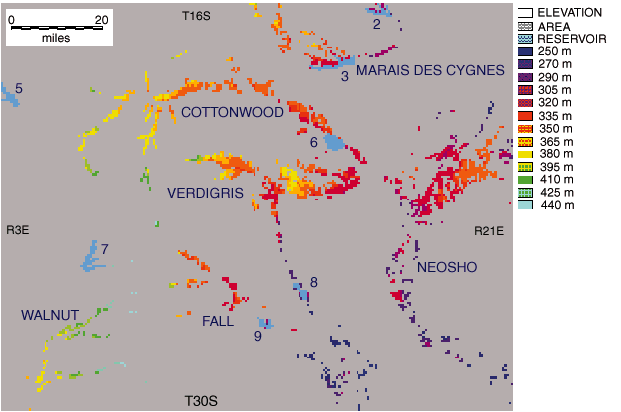
Fig. 8. Kansas chert gravel (Olpe Soil) map. Raster grid of upland chert gravel deposits (Olpe soil) in eastern Kansas, according to township-and-range grid. Each pixel represents one quarter section in area (0.25 mile2, 0.65 km2); pixels are color coded according to elevation classes. Numbers indicate man-made reservoirs: 2 = Pomona, 3 = Melvern, 5 = Marion, 6 = John Redmond, 7 = El Dorado, 8 = Toronto, and 9 = Fall. See also Fig. 2.
Upland chert gravel deposits are formally named the Leon Gravel after the city of Leon (Aber, 1992). A stratotype is designated in NE sec. 35, T. 27 S., R. 5 E. As defined, the Leon Gravel is equivalent to the Olpe or Olpe-Norge soil map units within the Walnut drainage basin of Butler and Cowley counties. The Leon Gravel is usually 1-2 m (3.3-6.6 ft) thick and rests on Permian bedrock. It can be informally separated in some places into upper and lower members on the basis of topographic position in relation to adjacent modern valleys. The upper member occupies hilltop or drainage-divide positions, about 18-30 m (60-100 ft) above modern floodplains. The Olpe soil B2 unit color is typically moderate to dark reddish brown (10 R 4/6 to 3/4). The lower member occupies high-terrace positions, roughly 6-12 m (20-40 ft) above modern floodplains. The Olpe soil B2 unit color is typically moderate brown (5 YR 4/4).
Upland chert gravels in the Walnut drainage basin are preserved almost exclusively on the northern sides of eastern tributaries--Little Walnut, Hickory, and Rock valleys--and on the eastern side of the lower Walnut valley. The same pattern holds true for lower (that is, younger) terraces within these valleys, and rivers are cutting bedrock bluffs in many places on valley sides opposite the terraces. Exotic pebbles are found within chert gravel deposits in all portions of the Walnut basin and are especially abundant along the lower Walnut valley.
![]()
Kansas Geological Survey
Web version March 18, 1998
http://www.kgs.ku.edu/Current/1997/aber/aber8.html
email:lbrosius@kgs.ku.edu