Prev Page--Contents || Next Page--Geography
Introduction
Purpose and History of Investigation
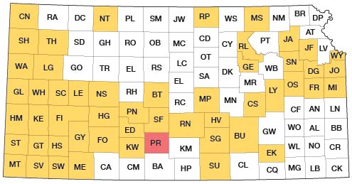
This report is part of a continuing program of ground-water investigations that was begun in 1937 to define and describe the occurrence, availability, and chemical quality of ground water in Kansas. Participants in the program are the U.S. Geological Survey and the State Geological Survey of Kansas, in cooperation with the Division of Environmental Health of the Kansas State Department of Health and the Division of Water Resources of the Kansas State Board of Agriculture. The present status of the program is shown on figure 1.
Fig. 1--Index map of Kansas showing area described in this report and areas covered by other online geologic reports, as of Aug. 2008. For additional information, please visit the KGS Geologic Maps of Kansas Page.

Nearly all water supplies in Pratt County are obtained from wells. Thus, ground water is one of the principal natural resources of the county. Although supplies in most of the county are adequate for most uses at the present rate of withdrawal, a better understanding of the quantity, chemical quality, and distribution of the ground water is needed to meet anticipated increases in water use and to guide the future development and management of the resource.
The results of cooperative ground-water studies have been published for most of the counties adjacent to Pratt County. The geology and ground-water resources of Stafford County were described by B. F. Latta (1950), and those of Reno County were described by C. K. Bayne (1956). Similar studies were made by C. W. Lane (1960) in Kingman County, B. F. Latta (1948) in Kiowa County, and T. G. McLaughlin (1949) in Edwards County.
Pertinent general studies include "Pleistocene Geology of Kansas," by J. C. Frye and A. B. Leonard (1952) and "The Geologic History of Kansas," by D. F. Merriam (1963). Other geologic and hydrologic reports are listed in the Selected References.
Since 1961, a continuing study of the chemical quality of the streamflow of the South Fork Ninnescah River has been in progress as part of the cooperative program between the U.S. Geological Survey and the Kansas State Department of Health. The objectives of this investigation are to appraise the quality of the streamflow and to identify the principal sources of and extent of natural and man-made pollution.
Methods and Scope of Investigation
Field work for this report was done in the summer and fall of 1951, from April to October 1964, and in August 1965. The work consisted of (1) geologic mapping, (2) inventory of 150 wells, (3) drilling of 145 test holes, (4) measurement of discharge of the South Fork Ninnescah River, North Branch Elm Creek, and Turkey Creek, and (5) collection of water samples for chemical analysis. The test drilling was done with auger and hydraulic rotary rigs owned and operated by the State Geological Survey of Kansas. Chemical analyses of water samples were made by the Division of Environmental Health of the Kansas State Department of Health.
Location and Extent of Area
Pratt County, in south-central Kansas, is bounded on the north by Stafford County, on the east by Reno and Kingman Counties, on the south by Barber County, and on the west by Kiowa and Edwards Counties. The county contains 20 townships and has an area of 729 square miles. The location of the county is shown on figure 1. Most of the county lies between 37° 30' and 37° 50' N. latitude and between 98° 30' and 99° 00' W. longitude.
Well-Numbering System
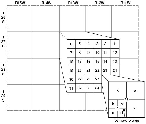
Wells and test holes in this report are numbered by their location according to the scheme of General Land Office surveys. The well number is composed of the township, the range, and the section number followed by letters that indicate the subdivision of the section in which the well is located (fig. 2). The first letter denotes the quarter section; the second letter denotes the quarter-quarter section or 40-acre tract; and the third letter, when used, indicates the quarter- quarter-quarter section, or 10-acre tract. The 160-acre (quarter section), or 40-acre, and 10-acre tracts are designated a, b, c, and d, in a counterclockwise direction beginning in the northeast quarter. Where two or more wells are located in a 10-acre tract, consecutive numbers beginning with 1 are added to the letters.
Fig. 2--Well-numbering system used in this report.

Acknowledgments
Appreciation and thanks are expressed to the many residents of Pratt County who supplied information on wells and to the city officials who supplied data on municipal water supplies. Special thanks are due to Mr. G. R. Calhoun, Soil Conservation Service Pratt, and to Mr. Stacy, the farm representative of the Peoples National Bank.
The cooperation of those who permitted the use of their wells for aquifer tests is gratefully acknowledged. Logs of selected wells were obtained from Dole Drilling Co. and Griffith Drilling Co.
Well records and water-quality data were programmed by members of the Kansas District, U.S. Geological Survey, for analysis and tabulation at The University of Kansas Computation Center. Field work was facilitated by the assistance of members of both the Federal and State Geological Surveys.
Prev Page--Contents || Next Page--Geography
Kansas Geological Survey, Geology
Placed on web Aug. 18, 2008; originally published Feb. 1973.
Comments to webadmin@kgs.ku.edu
The URL for this page is http://www.kgs.ku.edu/General/Geology/Pratt/02_intro.html