

Kansas Geological Survey, Open-file Report 90-23A
Hydrogeology and geochemistry of glacial deposits in northeastern Kansas: Test-hole and well data
by
Jane E. Denne, Rachel E. Miller, Lawrence R. Hathaway, and Howard G. O'Connor
KGS Open File Report 90-23A
The data in this open-file report accompany Bulletin 229, Hydrogeology and geochemistry of glacial deposits in northeastern Kansas, by Jane E. Denne, Rachel E. Miller, Lawrence R. Hathaway, and Howard G. O'Connor [available online].
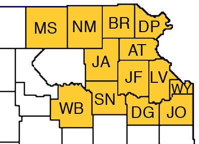
Part A contains the surface elevation, depth to bedrock, depth to water, well yield, well characteristics (total depth, date constructed, sand and gravel layers), uppermost bedrock unit, and record descriptions for wells in Atchison, Brown, Doniphan, Douglas, Jackson, Jefferson, Johnson, Leavenworth, Marshall, Nemaha, Shawnee, Wabaunsee, and Wyandotte counties.


Appendix A--Key to Well Log Data
Column entries from left to right:
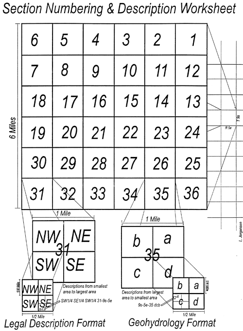
- a) Legal description (Township/Range/Section, 1/4 1/4 1/4)
- b) Type of record
- E = Public supply or industry test hole or well record from engineering or consulting firm. Where data maps unavailable, most entries field checked for location and elevation on topographic quadrangle maps.
- F = Well data from notes taken in field on topographic sheets.
- HE = Water well and test hole data from KDHE. Most entries field checked.
- IH = Water well and test hole data from Indian Health Service. Surface elevations estimated for given location using topographic maps.
- K = Test hole data from KDOT. Given locations and elevations checked against topographic maps for feasibility.
- KERC = Water well and test hole data from KERC reports. Surface elevations estimated for given location using topographic maps.
- M = Measured section.
- O = Oil and gas well or test hole record from KGS files, including Wards test data in Nemaha County Obtained directly from industry. Elevations from available log sheets, cards, and electric logs compared and checked against topographic maps for feasibility.
- OM = Oil and gas well or test hole record from missouri Geological Survey. Given locations and elevations checked against topographic maps for feasibility.
- OP = Core hole record from KGS file of Phillips Petroleum logs. Given locations and elevations checked against topographic maps for feasibility.
- PU = 1978 computer printout of Kansas well data from USGS.
- S = Well schedule from field inventory.
- T = KGS or USGS test-hole rotary or auger. Holes drilled from 1977-1983 were for this study.
- TA = KGS or USGS test-hole auger. Holes drilled from 1977-1983 were for this study.
- TR = KGS or USGS test-hole rotary. Holes drilled from 1977-1983 were for this study.
- TB = KGS or USGS test hole data from bulletin or other survey publication.
- TP = KGS or USGS test hole data from 1978 USGS printout.
- W = Water well record well (drilled since 1975). All entries field checked for location and elevation on topographic quadrangle maps.
- WB = Well records from bulletin or other survey publication.
- WT = Water well record test hole (drilled since 1975). All entries field checked for location and elevation on topographic quadrangle maps.
- WO = Old water well record well (drilled before 1975). Most entries field checked for location and elevation in earlier studies.
- c) Surface elevation (feet).
- d) Depth of bedrock below land surface (feet).
- e) Depth of water below land surface (feet) (DRY = dry hole).
- f) Date of water level measurement (month/day/year).
- g) Uppermost bedrock unit (color type).
| Color |
Type |
| B = Blue |
GR = Green |
W = White |
CO or COAL = Coal |
| BK = Black |
O = Orange |
Y = Yellow |
LS = Limestone |
| BR = Brown |
R = Red |
U = Unknown |
SH = Shale |
| G = Gray |
T = Tan |
|
SS = Sandstone |
- h) Well yield (gallons per minute) (DRY = dry hole).
- i) Date well constructed (month/day/year).
- j) Total depth of well (feet).
- k) Sand and/or gravel layers from X depth to Y depth (feet).
- FS = Fine sand
- S = Sand
- MS = Medium sand
- &= And
- CS = Coarse sand
- G = Gravel (may also include boulders)
- NONE = No gravel or sand
Notes:
- N = Data not available.
- ? = Questionable data
Kansas Geological Survey, Geohydrology
Placed online May 20, 2010
Comments to webadmin@kgs.ku.edu
The URL for this page is http://www.kgs.ku.edu/Hydro/Publications/1990/OFR90_23A/index.html


