Kahola Creek valley. High-terrace gravels are preserved along the northern side of a small east-flowing tributary of the Neosho in the southeastern corner of Morris County. These gravels contain no exotic pebbles, and the creek is cutting bedrock bluffs on the southern valley side.
Middle Neosho River valley. Nearly continuous trend of chert gravel is present on high terraces and hilltops along the northeastern side of the valley in Lyon and Coffey counties. Gravel elevations range from 10 m to 50 m (33-160 ft) above the adjacent floodplain. These gravels contain occasional sandstone and petrified wood along with relatively common exotic pebbles.
Southwestern Coffey County. Broad upland distribution of chert gravel is found on high terraces and local divides west of the Neosho valley. Exotic pebbles are common.
Anderson and northwestern Allen counties. Chert gravel is preserved in the vicinity of the Missouri-Arkansas drainage divide in central Anderson County at elevations of 350-360 m (1,150-1,180 ft) (fig. 10). These gravels are remarkable for the high degree of chert-pebble roundness and for the abundance of exotic pebbles. The chert gravels extend on hilltops as a broad belt from the divide downward to the southwest. This gravel belt merges with the high-terrace trend along the northeastern side of the Neosho valley at an elevation of about 310-320 m (1,020-1,050 ft).
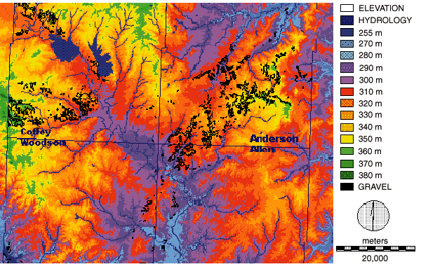
Fig. 10. Neosho chert gravel deposits. Digital elevation model for parts of Anderson, Coffey, Woodson, and Allen counties. Detailed distribution of upland chert gravel (Olpe soil) outlined in black; elevation classes shown by color coding. Model has 90 m (300 ft) resolution; derived and corrected from DEM-24K; UTM coordinate system. Digital elevation model obtained from the Kansas Geological Survey--DASC. Image processing by R. Byerley and N. Wilkins.
Lower Neosho River valley. Chert gravels occur along the western side of the valley in Woodson, Allen, and Neosho counties. High terraces are adjacent to and 10-20 m (33-66 ft) above the modern floodplain, whereas hilltop gravels form a discontinuous belt 30-40 m (100-130 ft) above and 6-8 km (3.7-5 mi) west of the valley. Exotic pebbles are found in both high-terrace and hilltop deposits.
In northeastern Greenwood County, the Verdigris River turns toward the south-southeast. Along most of this stretch, chert gravels bearing exotics are found west of the valley, and gravel occurs east of the valley in a few places. Near the junction with the Fall River, chert gravel caps the drainage divide between the two basins. Exotics are also found as isolated pebbles resting on bedrock terrain across north-central Greenwood County.
![]()
Kansas Geological Survey
Web version March 18, 1998
http://www.kgs.ku.edu/Current/1997/aber/aber10.html
email:lbrosius@kgs.ku.edu